Tuesday 26 November 2013

68-70 - Nottingham and Nottinghamshire - 20th September 2013

On my last blog post I had visited Whipsnade zoo and Dunstable downs (the highest point of Bedfordshire) with Nathan. it now it was time to continue our Journey north along the M1 until we reached Nottingham which was to be our home for 2 nights. We checked into our hotel and settled in ready for our short visit.

The Major Oak
The next day we were not going to be visiting any highpoints, instead we had a day in Nottingham, we headed into town on the Tram. Nottingham is quite a nice place, we walked to the castle in the torrential rain and looked around that, then we headed to the caves of Nottingham, a rather cool collection of underground rooms that have been used as housing, taverns and as an air raid shelter amongst other things. Next we played crazy golf, went to the cinema and finally had some dinner in the most amazing restaurant finishing the day with a tram ride back to the hotel ready for the next day when we would tackle some of the local high points.

Silverhill from a distance
The first thing we wanted to do when leaving our hotel was to head north out of Nottingham and into Sherwood forest, we headed straight for the town of Edwinstowe where we visited the Sherwood forest visitors centre. After a 20 minute walk into the forest we arrived at the Major Oak, This large English oak was said to be the meeting place of Robin Hood and his band of merry men. The oak is said to be 1000 years old and weighs in at 23 tons, it is huge, it is so big and heavy that it has to be held up by various supports. After a visit to the tree we headed back to the visitors centre for a look around the shop and information centre.

Silverhill

The top of Silverhill
 It was now onto our first highpoint of the day, it was going to be a tricky one as there was some confusion as to which hill was the highest point, I have several ways of checking out my highest points, firstly there is an online database listing all of the locations, secondly I have a book written by a guy who has visited them all, anyway the online database had the highest point as Newtonwoood lane near Mansfield and the book has it as Silverhill which is also not too far away from Mansfield, the problem with these locations is that one of them is an old man made hill, the other is a dull and boring, in the end I decided to visit both.

 First up was Silverhill, it sits on the site of the old Silverhill colliery which was closed in 1993, the hill here is actually a mine spoil heap and therefore man made but it is such a nice hill I think it is becoming classed as the highest point in Nottinghamshire, The walk to the top didn't take too long, we spent most of the time dodging the dog poo sadly, however when we reached the top we were greeted with a monument to the miners of the past and some amazing views. When admiring the view we noticed a huge building in the distance, after a little research we discovered it was a National trust property and as both Nathan and I are NT Members we decided a visit was the way to go so we headed back down Silverhill (or what we now affectionately call it Dog poo hill) to the car and headed off to our next destination.

Hardwick Hall
Hardwick hall is an amazing collection of buildings and gardens, the main building is Elizabethan but there are much older ruins on the same site, The property was built by the richest woman in England after Queen Elizabeth, Bess of Hardwick. We spent a good amount of time here viewing the house and seeing all the fabrics and tapestries, we later found out that the house was used as Malfoy Manor in the Harry Potter films. If you are even in the area it is well worth a look around the huge estate.


Newtonwood Lane
Our next point of call was the second highpoint of the day, Newtonwood lane, this was just a 20-30 minute drive away and was rather unimpressive as it is the site of a reservoir. we didn't stay here long, we decided it was time to head off home to Portsmouth as it had been a rather full few days. There was one more highpoint I had to visit on the route home however and this one could have proven difficult but I decided to make it easy and cheat a little. 

The highest point of the Unitary Authority of Nottingham can be found on the M1, not next to or near the M1 but actually on the M1, this is not going to be one I could stop at and get out for a walk around so as we drove over the highpoint on the way home I got Nathan to snap a photo of me driving. After this we continued our journey home to Portsmouth after a rather nice few days away.

Driving over the highest point of the UA of Nottingham

Monday 25 November 2013

67 - Dunstable Downs - Bedfordshire - 18th September 2013

Dunstable Downs is the highest point of Bedfordshire and it overlooks the town of Dunstable which lies to the north, this highpoint was going to be a really easy visit as the very top if the hill sits right next to a National Trust car park, What this means is that rather than just drive straight to the car park I wanted to make the visit a little bit more exciting, I could have parked at the bottom and climbed up but in the end I opted for a much more fun thing to do, just a small distance down the road is Europe's largest wildlife conservation park, Whipsnade zoo, I don't think I could visit the area without a visit to Whipsnade. Dunstable downs was also going to be the first of several highpoints over the next few days.


I left Portsmouth with Nathan by my side and drove the 2 hour journey, up the A3 through Petersfield and Guildford, and then around the M25 and up the M1 to Whipsnade zoo. We entered the zoo and headed straight for the walk through lemur enclosure, we were immediately pointed in the right direction by a member of staff and we found the lemurs all cuddled up next to a rock. after this we headed further into the park towards the sealion pool. we soon came aware of something sitting on the grass ahead of us, I first thought it was a dog but it was the wrong shape, it was sat really still so I thought it was maybe a statue, as we approached it became apparent that it was one of the zoo animals, had it escaped? was it loose? did we need to run for our lives screaming with terror? no, it was fine, we found out later that there were several types of animal who were free to roam the whole park, we later found out that this animal was called a Mara, a larger relative of the guinea pig from South America.


We continued around the park seeing the sea lion show next followed by a steam train ride around the park. From the train we saw Elephants, Camels, deer, bison and all kinds of other animals, what was so impressive about this was the huge amount of space the animals had to move around in, it was like looking out across the Savannah. After the train ride we saw so many more animals including Zebras, 2 types of bear, Cheetah, Lions, Rhino, Giraffe, 2 types of hippo, wolves, moose, reindeer, penguins, wolverine, Chimps, mongoose, wallaby and so many other animals, I really was impressed with the amount of space the animals had to wander around in.


Towards the end of the visit to Whipsnade we were wandering along one of the roads when suddenly we saw a herd of elephants out for a walk, the amazing thing was the fact that they were not in an enclosure, they were just wandering around the park with a few keepers to stop the visitors getting too close, how very cool is that? free roaming elephants.


After having such a cool day at Whipsnade we left and made our was the short distance to the top of Dunstable downs, the highest point in Bedfordshire. We parked in the car park and walked the 20 meters to the trigpoint for some photos. Just a small walk from the car park was a visitors centre and then beyond that there were some amazing views to the north. We stayed for a while to admire the views and then it was time to head off to out next destination 2 hours drive north along the M1.


Wednesday 6 November 2013

66 - Whitehorse Hill - Oxfordshire - 11th September 2013

On Monday the 9th of September I headed up to Wolverhampton for a non high point 2 day related event which turned out to be a huge waste of my time and a total disappointment, so on the morning of Wednesday the 11th I felt the need to do something to cheer me up, I searched my maps and found a high point and headed off from Wolverhampton down the M5 towards Gloucestershire and then eventually arriving at Whitehorse Hill, the highest point of Oxfordshire.


Whitehorse hill as the name suggests has a White horse on it, the hill lies to the east of Swindon near the village of Uffington in the south west corner of Oxfordshire, the land is owned by the National trust so I parked in the NT car park for free and headed off for a walk to the top of the hill.


I left the car park and headed east for a while, from the very start the views across to Swindon were amazing. While walking I noticed a bird hovering over the path ahead of me and when I approached I saw it was an amazing bird of prey, it just stayed hovering above me for ages and was quite an amazing sight. I continued along the past and crossed a small road but now the path rose a bit more steeply and I was soon approaching the top of the hill where a trig point marked the spot.


I stopped around the top of the hill for a few moments to admire the view and take a few photos and then I headed off to explore more of the area, the top of the hill is dominated by an ancient iron age hill fort called Uffington castle. You can make out the location of the castle from the huge banks and ditched carved into the top of the hill and as I walked around I found the location of some of the gates into the fort. After walking around the edge of the castle I decided it was time to head back to the car and continue on my journey home. It was just a short walk back to my car, I was so pleased I had stopped off on my way home after such a disappointing 2 days in Wolverhampton.


Whitehorse hill is worth a visit if you are in the area, it has some beautiful views and very interesting features.


Sunday 29 September 2013

65 - Wentwood - Newport - 1st August 2013

I was on day 3 of my trip to Wales to climb a few highpoints and today was the day I was due to travel back home again. It had been a went night but by the time I had woken up the next morning the sun was out and it was now a glorious sunny day so I was able to pack away while drying everything out at the same time, this included both my cameras (not good) and most of my clothes which had gotten wet the day before, thankfully it all dried out quickly and both the cameras still work perfectly.

Once I was all packed up I left the campsite and made my way from Pencelli Castle south towards Abergavenny and then on towards Newport, before I reached the M4 I turned east and drove for about 20 mins until I reached a car park not too far from today's high point. This was Wentwood, a large area of ancient woodland in Monmouthshire and not too far from the Welsh/English border.

I left the car in the car park and walked into the woodland along a rather large path, this path soon turned out to be the main road in and out of the woodland for some tree felling work going on but I managed to avoid all of the machinery. I soon left this main path and took what looked like a really old path further away from the main path.


Eventually after a few turns and other paths I reached an area which was the highest point of the unitary authority of Newport, it was only a 20 min walk from the car park but I didn't have too much time and I had a lot of travelling to do. I stayed around here for a while and had a bite to eat but It was not long before I wandered back to my car.


Once I was back at my car I drove the rest of the way home after an excellent few days of climbing, camping and high points.


Sunday 22 September 2013

64 - Pen y Fan - Powys - 31st July 2012

Pen y Fan is not only highest point of Powys but also the highest point of the Brecon Beacons, the highest point of South wales and it is the highest point in southern UK, I knew this was going to be a challenge.

This was not my first visit to Pen y Fan, I visited the Brecon Beacons when I was 15 and climbed the mountain then, I remember it well, it was very hot and very sunny, today however was going to be quite a different climb. The Pencelli Castle campsite where I was staying was about 7 miles away from the top of Pen y Fan so I decided to walk all the way, I left the campsite around 10am and headed out of the village and past the Monmouthshire and Brecon canal.

After passing through the very quiet village of Llanfrynach I left the road for the first time and headed cross country along some footpaths and down by the side of a river, up until now it had been very dry but the rain started to fall and so I got the waterproofs out and carried on. After following the river for some time I veered off and headed across some fields, apart from passing the occasional farm worker I saw no one, it was very quiet and rather nice to have such peace and quiet, its not often we experience that in this modern world we live in. Eventually I walked through a farm and I was back on the road for the next mile or so.

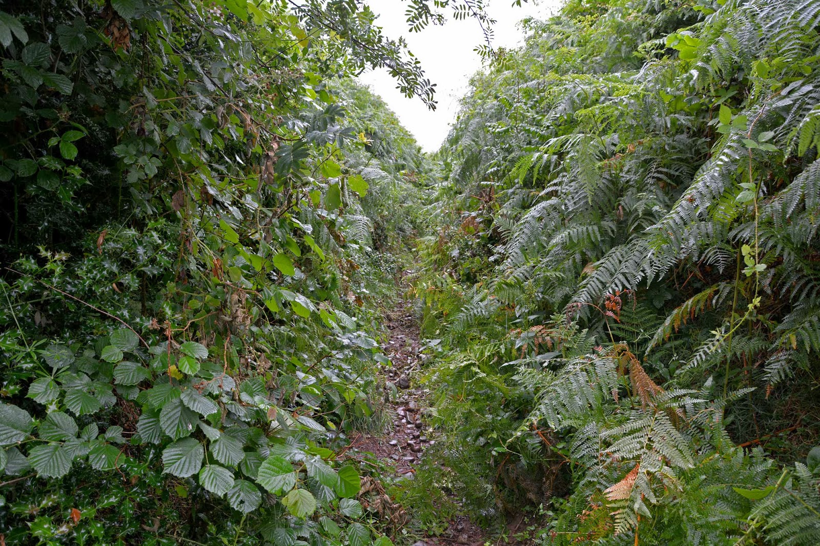
The road zig-zagged its way through the fields and over rivers (and waterfalls) and I soon turned left down a smaller road finally heading towards the mountains. The path ahead was clearly marked on my map, a nice straight pathway leading to the edge of the Brecon Beacons national park, easy I thought, however when I reached this path I found it was badly over grown, I couldn't see very far along the path and I didnt really know what to do, if turned back it would add a mile or more onto my walk, if I carried on there was no guarantee I could find my way along the path.

I decided to try the path, the rain had stopped and I was after adventure so I headed along the path. I had managed up until this point to stay relatively dry from the rain but after about 2 minutes of walking along this path I was soaked, the ferns on each side of me were wet and I was getting wet from the plants above and below, not only was I trying to avoid getting too wet but I was trying to avoid the stinging nettles, thorns, bramble and almost every other type of attacking weed you can think of.

It took me about 30 minutes to navigate this path, by the time I had reached the end I was soaking wet, scratched and stung on my legs, also I was worn out from climbing my way through the undergrowth, it was a bit like working my way through a jungle and think I could have done with a machete. I had finally reached the gate onto the Brecon beacons national park so I stopped for a few minutes and had a bit of tea from my flask, changed some of my clothes for dry ones and headed through the gate and up the first major slopes towards the top of my first mountain of the day.


The climb upwards started almost immediately, there were a few sheep around and the path worked its way up, the cloud was thick above me and the rain was back again along with the wind, I could tell I was getting higher. Very soon the path had taken me up into the clouds and the visibility was down to about 50ft. There were a couple of people heading in the same direction so I walked along with them for a while and kept them in sight, After about 30/45 mins climbing the path suddenly took a change in direction, not to the left or right but vertically, it had been a steady climb so far but suddenly it changed to a very steep climb, I was having to clamber over boulders and work my way up steep steps.

The Summit of Cribyn
I eventually reached the top of this first mountain, this was Cribyn, a typical looking mountain with a pointy top, at 795 mts high is was not my final high point but it was still excellent to get to the top, The wind here was really strong so I didn't stop, I carried on to my next mountain and highest point. The Path from the top of Cribyn went back downhill immediately but not for too long, it soon became a flat path for a short while and after crossing a small marshy area it started to head uphill again. The path weaved its way around large boulders but it was not as steep as the path up to the top of Cribyn, it was still a tough climb though, It was along this path I passed 3 other people going in the other direction, these were the only 3 people I saw on the slopes on Pen y Fan.

The Summit of Pen y Fan
I soon reached the summit of Pen y Fan, it is 886 meters high and the weather was crazy at the top, the wind was so strong and it was mixed with rain so I took a couple of photos and then managed to find a sheltered corner among some boulders where I could have a cup of tea and a bite to eat. I didn't stay at the top long as the weather really was horrible so I headed back down the slopes of Pen-y Fan along a path that would take me back down without having to climb Cribyn again.


The path from the top of Pen y Fan took me along the top of some pretty cool ridges, sadly I couldn't see too much as the cloud was obscuring my view, it was not too long before I was back down out of the bad weather. I worked my way back down the path over a few more hills and past the sheep and around the edge of a final hill, finally coming out of the National park and back into the farm land and countryside of Wales.

After leaving the national park I headed through a farm and along a few roads and then I was back on the same roads I used earlier in the day, all I needed to do was retrace my steps back to the campsite and back to a nice hot shower, dry clothes and a lovely barbeque and relax.

This climb was amazing, I couldn't see much of Pen-y-Fan but it was still an awesome climb and one I will remember for a long time. 

Tuesday 13 August 2013

62-63 - Merthyr Tydfil and Caerphilly - 30th July 2012

This week I had decided to head back to South Wales to climb 4 high points, I was camping again and headed off to a wonderful campsite a few miles south east of Brecon called Pencelli Castle. I arrived early afternoon and set up my tent and base camp for the next 3 days, it was a beautiful sunny day with just a bit of cloud, perfect camping weather.

After setting up my tent I headed towards Brecon and then down through the Brecon Beacons along the A470 to Merthyr Tydfil. One of the most difficult things about my the high points tody were finding somewhere to park, I started off not too far from the Brecon mountain railway but could not gain access to the area I needed to climb from here, next I stopped at the village of Pant, after a short walk I found there was a farm in the way with no access through to the high point.

The next place to stop was a small road to the east of the high point but there was no area to park and it did look like private property, finally I parked on the side of a road near 3 horses and a gate giving me access to the area I needed to climb. I passed through the gate and past the horses and slowly climbed up towards a reservoir, it was actually a pretty hard walk to start with as the ground was so uneven and the paths were pretty non existent, I did manage to find a few sheep trails to follow but it was not long before I had reached my high points.

Now because of the way the borders are in this area there are 2 high points very close to each other, within a matter of minutes I had visited both of them, the disappointing thing however was that because a third border runs through the area none of the high points were actually on the highest ground in the area, so there I was standing half way up a hill on the highest point of the Unitary Authorities of Caerphilly and Merthyr Tydfil.


The walk back to the parking spot was uneventful until I met the horses again and they seemed to take a liking to me and followed me all the way to the gate, then it was back to the campsite for my first camping dinner of the week.

Both Merthyr Tydfil and Caerphilly High points were rather disappointing due to the fact that there was much more amazing scenery just a short distance away however I am pleased I did it and it was worth the relatively short walk.

Monday 29 July 2013

61 - Chwarel y Fan - Monmouthshire - 3rd July 2013

It was time for another climb on this short camping trip away and I headed out of the campsite and back past Black mountain (the subject of yesterdays climb) and down the gospel path to the tiny village of Llantony. I parked in the car park next to an old yellow car and took a quick look around Llantony Priory, a partly ruined Augustine Priory. The Priory is now the sight of a small b&b and a campsite.

After the quick look around the priory I headed off through the village and down to the river where I had to find the bridge to cross over, I asked directions and found the little bridge to cross the river. The path went along the edge of the river for a short distance and then headed up a valley and over a few styles and through a few fields of sheep. Eventually the path left the fields and became steeper, it was totally surrounded by ferns and was a rea
lly pretty walk.

It was along this part of the path that I discovered a lady looking for her friend, he had gone wandering off to find the correct path and she had lost him, anyway, I said I would look out for him, about 20 mins later I eventually saw him, walking back down the path, he had no map and mobile phone, and he had not a lot of idea about where he was going but he was soon reunited with his friend. Its crazy to think how easy it is to get lost on the mountains with no maps or communication.

I carried on climbing up the mountain and eventually reached another path heading north/south along the tops of the mountains, there was a big pile of stones here but I still had a lot of walking to do. The route I took now headed north and I had another steep climb to do and eventually I made it to the top of Bal Mawr, it was now a fairly steady and lever walk of nearly 2 miles to the highest point.

After walking for about 40 mins along the tops of the mountains I eventually arrived at the highest point, at 679 meters (2228 feet) Chwarel y Fan is the highest point of Monmouthshire. There were rather amazing views from the top, to the north east was Black Mountain, the subject of my last high point and then to the west were the rest of the B
recon Beacons. I stayed on the top for about half an hour while I had a cup of tea and some lunch and then it was time to retrace my steps back down the mountain and back to the car park.

The walk back was rather uneventful, apart from passing 2 people climbing up the mountain I saw no one else for the walk back down and I was back at the car in around 90 mins. Chwarel y Fan was an awesome climb and the views were spectacular, with plenty of other mountains in the area it was a brilliant climb. Once I was back at the car I headed into Hay and Wye for a quick look around and then I was back to the tent for my last night of camping.